Make sure to read the full region forecast it has more complete details on the incoming swell and regional conditions. Click here for the full forecast www.socalsurf.com.
More high-tide lameness on tap for Saturday morning but we will have a few spots (that can handle the tide) pulling in some new surf from the building WNW-NW swell. Expect those areas to have chest-shoulder high surf with some inconsistent head high sets mixing in. As the tide drops we can expect more of the average WNW facing spots to move into the chest-head high range and the standout winter spots in North County to see overhead surf, even a couple of feet overhead on the biggest sets.
Sunday will have similar sizes (and a similar big fat morning tide)…so expect a bit of a slowdown early in the morning but then improving size, shape, and consistency as the tide drops off.
Winds look a little tweaky on Saturday…sort of light/variable to light onshore for the morning with more texture showing at the really open beaches. WNW-NW winds come onshore around 10-15+ knots for the afternoon. Sunday looks cleaner with light offshore flow for the morning and mostly calm to variable onshore flow holding through most of the day.
Here are the tides…have a great weekend…
01/30/2010 Saturday
02:30AM LST 1.2 L
08:31AM LST 6.6 H
03:35PM LST -1.5 L
09:48PM LST 4.6 H
01/31/2010 Sunday
03:20AM LST 0.9 L
09:18AM LST 6.2 H
04:12PM LST -1.2 L
10:25PM LST 4.8 H
Showing posts with label high tide swamp. Show all posts
Showing posts with label high tide swamp. Show all posts
Friday, January 29, 2010

Thursday, January 28, 2010
Orange County Surf Forecast - for Friday - 1/29/2010
Make sure to read the full region forecast it has more complete details on the incoming swell and regional conditions. Click here for the full forecast www.socalsurf.com.
We get pretty swamped by the tide in the morning…look for very mushy/shorebreaky shape for pretty much everywhere (of course with a couple of exceptions at the few breaks that like the extra water). Once the tide drops we can expect surf in the knee-waist high+ range for most breaks exposed to the fading WNW-NW energy and the small S-SSW pulse that is hanging in the background.
New WNW-NW swell (280-300) starts filling in later in the day…possibly helping to increase size and consistency a touch at the best NW facing breaks as we head toward the end of the day. I am not expecting a ton of new surf before the sun sets, but it will be worth at least giving the top spots some sort of check if the winds seem light.
Light and variable to light offshore winds for the morning. WNW-NW winds around 10-15 knots expected for the afternoon…possibly lightening up around sundown.
Here are the tides…
01/29/2010 Friday
01:40AM LST 1.4 L
07:44AM LST 6.6 H
02:58PM LST -1.7 L
09:13PM LST 4.2 H
We get pretty swamped by the tide in the morning…look for very mushy/shorebreaky shape for pretty much everywhere (of course with a couple of exceptions at the few breaks that like the extra water). Once the tide drops we can expect surf in the knee-waist high+ range for most breaks exposed to the fading WNW-NW energy and the small S-SSW pulse that is hanging in the background.
New WNW-NW swell (280-300) starts filling in later in the day…possibly helping to increase size and consistency a touch at the best NW facing breaks as we head toward the end of the day. I am not expecting a ton of new surf before the sun sets, but it will be worth at least giving the top spots some sort of check if the winds seem light.
Light and variable to light offshore winds for the morning. WNW-NW winds around 10-15 knots expected for the afternoon…possibly lightening up around sundown.
Here are the tides…
01/29/2010 Friday
01:40AM LST 1.4 L
07:44AM LST 6.6 H
02:58PM LST -1.7 L
09:13PM LST 4.2 H
Thursday, November 19, 2009
Orange County Surf Forecast – Friday – On the way down…but still fun
The Swell
The mix of WNW-NW swell (280-300 but with more energy in the 290-300 range) and some weak SW swell (200-220) will back down on Friday. Look for the biggest, most consistent surf through the morning and further shrinkage by the afternoon.

Waves
Look for smaller but still fun/rideable surf on Friday. The average exposed spots will be in the waist high range…maybe even a few chest high sets through the morning. Standout NW exposed spots will be in the chest-shoulder high range…with a few North County plus sets early in the morning. Looks like shape will continue to be a little wally at the beach breaks so the best shape will be at spots that have something to break up the swell a little bit better.
Winds
Look for light and variable winds through the morning…even a few pockets of light E-ESE-SE offshore winds in some areas. Increasing clouds and light/moderate NW winds 10-14 knots move in through the afternoon. Chance for some light showers later in the night.
Orange County Tides
11/20/2009 Friday
03:45AM LST 2.8 L
09:58AM LST 5.4 H
05:53PM LST 0.1 L
The mix of WNW-NW swell (280-300 but with more energy in the 290-300 range) and some weak SW swell (200-220) will back down on Friday. Look for the biggest, most consistent surf through the morning and further shrinkage by the afternoon.

Waves
Look for smaller but still fun/rideable surf on Friday. The average exposed spots will be in the waist high range…maybe even a few chest high sets through the morning. Standout NW exposed spots will be in the chest-shoulder high range…with a few North County plus sets early in the morning. Looks like shape will continue to be a little wally at the beach breaks so the best shape will be at spots that have something to break up the swell a little bit better.
Winds
Look for light and variable winds through the morning…even a few pockets of light E-ESE-SE offshore winds in some areas. Increasing clouds and light/moderate NW winds 10-14 knots move in through the afternoon. Chance for some light showers later in the night.
Orange County Tides
11/20/2009 Friday
03:45AM LST 2.8 L
09:58AM LST 5.4 H
05:53PM LST 0.1 L
Sunday, November 15, 2009
Orange County Surf Forecast – Monday – Small and Clean
The Swell
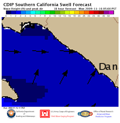
We will have a mix of small WNW-NW windswell, some weak SW swell (190-210), and some new, but background, NW swell (295-300) from a little further out in the NPAC.
Waves
Thanks to the morning high tide most spots will be pretty small for the dawn patrol…though a few of the shallower sand bars may see some inconsistent sets. As the tide drops look for the average breaks to fill in to about knee high with some inconsistent waist high sets. The standout combo spots, that can mix the windswell and SW energy, will be more in the waist high range but I wouldn’t rule out some chest high sets as the tide drops.
Winds
Light offshore to light and variable winds on tap through the morning and W-WNW winds around 10-12 knots for the afternoon. Looks clean through the first half of the day.
Light and variable to light offshore winds will be on tap Sunday morning. NW winds 10-15+ knots move in through the afternoon.
Orange County Tides
11/16/2009 Mon
01:37AM LST 1.9 L
07:46AM LST 6.3 H
03:07PM LST -0.8 L
09:24PM LST 3.8 H
We will have a mix of small WNW-NW windswell, some weak SW swell (190-210), and some new, but background, NW swell (295-300) from a little further out in the NPAC.

Waves
Thanks to the morning high tide most spots will be pretty small for the dawn patrol…though a few of the shallower sand bars may see some inconsistent sets. As the tide drops look for the average breaks to fill in to about knee high with some inconsistent waist high sets. The standout combo spots, that can mix the windswell and SW energy, will be more in the waist high range but I wouldn’t rule out some chest high sets as the tide drops.
Winds
Light offshore to light and variable winds on tap through the morning and W-WNW winds around 10-12 knots for the afternoon. Looks clean through the first half of the day.
Light and variable to light offshore winds will be on tap Sunday morning. NW winds 10-15+ knots move in through the afternoon.
Orange County Tides
11/16/2009 Mon
01:37AM LST 1.9 L
07:46AM LST 6.3 H
03:07PM LST -0.8 L
09:24PM LST 3.8 H
Friday, November 13, 2009
Orange County Surf Forecast – Weekend Waves – The windswell continues
The Swell
WNW-NW windswell will peak into early Saturday, fade slightly through midday and then increase again in the afternoon. Look for the windswell (and a small SW swell) to fade through the day on Sunday.


Waves
Saturday looks pretty ugh…high tide and building onshore winds will keep things from ever getting very surfable…though there may be a couple of random surf pockets if you have a spot that can handle the mix of tide/windswell. Most breaks will be in the knee-waist high range while the standout NW windswell spots see some waist-chest high sets.
Sunday looks cleaner but the tide will continue to be an issue…more knee-waist high waves on tap for the morning…with a few chest high sets sneaking in as the tide drops. Look for smaller, less consistent, surf by the afternoon.
Winds
Saturday will see variable onshore flow for the morning…mostly below 10-knots but starting to get some texture on the water early (if it ever lets up from Friday night). Look for NW winds around 10-20 knots for the afternoon.
Light and variable to light offshore winds will be on tap Sunday morning. NW winds 10-15+ knots move in through the afternoon.
Orange County Tides
11/14/2009 Saturday
12:30AM LST 1.2 L
06:44AM LST 6.1 H
01:47PM LST -0.4 L
07:50PM LST 4.0 H
11/15/2009 Sunday
01:05AM LST 1.6 L
07:15AM LST 6.3 H
02:28PM LST -0.7 L
08:38PM LST 3.9 H
WNW-NW windswell will peak into early Saturday, fade slightly through midday and then increase again in the afternoon. Look for the windswell (and a small SW swell) to fade through the day on Sunday.


Waves
Saturday looks pretty ugh…high tide and building onshore winds will keep things from ever getting very surfable…though there may be a couple of random surf pockets if you have a spot that can handle the mix of tide/windswell. Most breaks will be in the knee-waist high range while the standout NW windswell spots see some waist-chest high sets.
Sunday looks cleaner but the tide will continue to be an issue…more knee-waist high waves on tap for the morning…with a few chest high sets sneaking in as the tide drops. Look for smaller, less consistent, surf by the afternoon.
Winds
Saturday will see variable onshore flow for the morning…mostly below 10-knots but starting to get some texture on the water early (if it ever lets up from Friday night). Look for NW winds around 10-20 knots for the afternoon.
Light and variable to light offshore winds will be on tap Sunday morning. NW winds 10-15+ knots move in through the afternoon.
Orange County Tides
11/14/2009 Saturday
12:30AM LST 1.2 L
06:44AM LST 6.1 H
01:47PM LST -0.4 L
07:50PM LST 4.0 H
11/15/2009 Sunday
01:05AM LST 1.6 L
07:15AM LST 6.3 H
02:28PM LST -0.7 L
08:38PM LST 3.9 H
Wednesday, November 11, 2009
Orange County Surf Forecast – Thursday – More leftovers…and building lump
The Swell
Not much change out there in the morning…the NW swell (290-300) will continue to wind down along with the weak SW swell (200-220). Local WNW-NW windswell will start to increase late in the day but won’t put many new waves on the beach until Friday.

Waves
The combo of fading swell and a lovely 5’+ morning high tide is going to shut off surf for many spots. Look for flat to knee high waves for the average spots during the dawn patrol…and a few waist highers at the top spots. We will get a slight improvement as the tide drops…more in the knee high+ range for the average spots and knee-waist high+ at the standout spots...unfortunately it will be a race to see if the tide drops or the winds pick up first. Personally I think that the wind is going to win tomorrow.
Winds
Mostly light and variable onshore winds and a bunch of areas with minor texture for the morning. Look for some moderate W-WNW winds in the 10-15+ knot range for the afternoon.
Orange County Tides
11/12/2009 Thursday
05:39AM LST 5.5 H
12:18PM LST 0.7 L
06:02PM LST 4.2 H
11:54PM LST 1.0 L
Not much change out there in the morning…the NW swell (290-300) will continue to wind down along with the weak SW swell (200-220). Local WNW-NW windswell will start to increase late in the day but won’t put many new waves on the beach until Friday.

Waves
The combo of fading swell and a lovely 5’+ morning high tide is going to shut off surf for many spots. Look for flat to knee high waves for the average spots during the dawn patrol…and a few waist highers at the top spots. We will get a slight improvement as the tide drops…more in the knee high+ range for the average spots and knee-waist high+ at the standout spots...unfortunately it will be a race to see if the tide drops or the winds pick up first. Personally I think that the wind is going to win tomorrow.
Winds
Mostly light and variable onshore winds and a bunch of areas with minor texture for the morning. Look for some moderate W-WNW winds in the 10-15+ knot range for the afternoon.
Orange County Tides
11/12/2009 Thursday
05:39AM LST 5.5 H
12:18PM LST 0.7 L
06:02PM LST 4.2 H
11:54PM LST 1.0 L
Wednesday, November 4, 2009
Orange County Surf Forecast – a good day for chores
The Swell
Small and inconsistent SW swell (200-220) will mix with fading NW leftovers and background local windswell.

Waves
Surf will be flat to about knee high for most of the average spots tomorrow…and by knee high I mean “knee high shorebreak” not very many rideable waves. Top SW facing breaks in South County will be a touch bigger but still not all that fun…basically the best breaks can expect more consistent knee-high sizes with a couple of knee-high+ sets on the lower tides. High tide will kill it off almost everywhere by midmorning.
Winds
Winds will be mostly light/variable in the morning with a few pockets of light onshore texture, particularly around the random fog banks. Look for W-SW winds coming onshore around 10-13 knots by the afternoon.
Orange County Tides
03:16AM LST 2.4 L
09:33AM LST 6.2 H
05:16PM LST -0.6 L
11:57PM LST 3.5 H
Small and inconsistent SW swell (200-220) will mix with fading NW leftovers and background local windswell.

Waves
Surf will be flat to about knee high for most of the average spots tomorrow…and by knee high I mean “knee high shorebreak” not very many rideable waves. Top SW facing breaks in South County will be a touch bigger but still not all that fun…basically the best breaks can expect more consistent knee-high sizes with a couple of knee-high+ sets on the lower tides. High tide will kill it off almost everywhere by midmorning.
Winds
Winds will be mostly light/variable in the morning with a few pockets of light onshore texture, particularly around the random fog banks. Look for W-SW winds coming onshore around 10-13 knots by the afternoon.
Orange County Tides
03:16AM LST 2.4 L
09:33AM LST 6.2 H
05:16PM LST -0.6 L
11:57PM LST 3.5 H
Subscribe to:
Posts (Atom)


 Posts
Posts


